Historical Photographs
Photographs of Eaton Bray
This page will be updated gradually as more historical photographs of Eaton Bray and the surrounding villages are made available.
If you have any photos yourself that you are happy for us to reproduce on the website, please Contact Us with details, or use the Submit Content page to send them directly to us.
Millennium Book
 The Eaton Bray Millenium Book, A Century of Change was provided compliments of Eaton Bray Parish Council as part of their Millennium celebrations.
The Millenium Book contains many historical photographs from around Eaton Bray, including comparisons of views circa 1900 and 1999.
Photographs from around Eaton Bray
Each of the photographs below can be clicked in turn to view the full version.
If you know any of the missing names below, or think any of the names shown are wrong, please get in touch and tell us.
 Eaton Bray Football Club, Beds Inter Final 1961-62 (provided by Dawn Clarke) Back Row: Palmer, Burrows, Ashton, Bateman, Costin, Bright, Burrow, Clarke, Galloway, Pipkin, Simmons Front Row: Macaclan, Hills, Barling, Munt, Galloway, Earwicker, Rutherford | 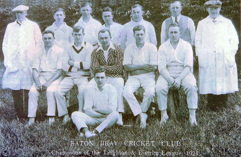 Eaton Bray Cricket Team 1924 Back Row: Earnest Gray - ??? ??? - Bill Neville - Frank Bates - Harry Pratt - Jim Bates - Arthur Andrews Middle Row: Dave Bliss - Tommy Henley - Harold Hebbes - Ted Pratt - Vic Price Front Row: John Thorne |
 Eaton Bray School Football Team 1907 Back Row: Sid Gadsden, Fred Bates, William Peters Paddock, Dick Lugsden, Archie Horton Middle Row: Bill Neville, ????? Janes, Abel Groom, Banty Clarke, Fred Tooley Front Row: Ernie Weedon, Johnny Pratt, Cyril Meakins |  Eaton Bray High Street - Looking up from Woodside |
For more photos and discussion of Eaton Bray and Surrounding Villages History, please
join Tom 'n' Harry's Facebook Group - facebook.com/groups/1521904144763444
The next photograph is kindly provided by Ron Evans.
| Eaton Bray Primary School, Miss Jackson's Class 1954 |
 Eaton Bray Primary School, Miss Jackson's Class 1954 (Back) Miss Jackson, Alan Stock, Margaret Sanders, Colin Goodyear, Norma Mardell, David Powell, Ron Evans (3rd row) Gerald Cook, Andrew Fountain, Jimmy Isherwood, Bruce Wiseman, Darryl burrows, Rod Ashton, ????, ???? (2nd row) Laura Benson, Shirley Horne, Diane Piggott, (?)Michael Buckingham(?), Brenda Bird, Rose Clarke, Linda Reed (Front) Sandra (Gadsden?), Diane Robson, Graham Blake, Shirley Blake |
| Can you help with any of the other names? Get in touch and let us know. |
The next four photographs show the Five Bells Produce Day, c1950s, and include Eric Ruffett, Richard Thorne, Jack Wood, Tony Rogers, Harry Ashwell and Landlord Wally Aylott aka Rhubarb.
 Five Bells produce day, c1950s |  Five Bells produce day, c1950s |
 Five Bells produce day, c1950s |  Five Bells produce day, c1950s |
The next four photographs are kindly provided by Dawn Clarke.
 Eaton Bray Football Team - South Midlands League Winners 1953 Back Row Bill Sharratt - Basil Maunders - Ken Bearton - Bob Lines - Harry Savings Front Row Ron Horn - Basil Ruffett - Harry Witts - Frank Ashton - Joe Bates - Tom Burrows |  Eaton Bray Cricket Team 1951 / 52 Back Row: Dennis Maunders - Basil Ruffen - Len Garwood - Fred Simmons - Harold Pratt - Bill Court Middle Row: Jess Thorne - Horace Rollings - Frank Pipkin - Hughie Davey - Jack Pratt - Basil Maunders Front Row: Derek Maunders |
 Chequers Pub Outing, circa mid 1950s |  Poplar trees being felled at the corner of Northall Road and High Street, circa 1950s Photographer John Bodsworth |
| Ron Evans has written about the tree felling |
Each photo can be clicked in turn to view the full version.
Photographs of Eaton Bray Vicarage
We have been kindly sent these photographs of the old vicarage by Patrick Graham whose father Peter was vicar of Eaton Bray from 1955 to 1963. The vicarage was the original site for the village fete (its a tad bigger now) and had a nearly 3 acre garden and large pond. In the picture Patrick is the toddler next to his father. You can find more on Peter Graham at http://peter.graham.muchloved.com/
 The Vicarage, circa early 1960s |  Patrick Graham outside the Vicarage with "Mrs Binity", circa early 1960s |
Each photo can be clicked to view the full version.
Map of Eaton Bray, 1826
Below is a map of Eaton Bray kindly provided by John Mickleburgh. It is taken from a folding map, hence the line across the middle.
This map is from the Actual Survey carried out by A. Bryant in the years 1825 and 1826. The full map was "respectfully dedicated to the Nobility, Clergy and Gentry of the County".

Click the image to open a full sized version in a new window.
Surrounding Area
Photographs of Edlesborough
This photograph of The Travellers Rest 1890/1900 was kindly provided by Derek Gray.
 The Travellers Rest 1890/1900 showing Derek Gray's ancestral relative Amos Gray and his wife Mary Honour |
The photographs below are kindly provided by Dawn Clarke.
Each photo can be clicked in turn to view the full version.
 Edlesborough Football Team, 1930 |  Edlesborough Cricket Team, circa 1955 |
 Edlesborough Girl Guides & Brownies, 1952 |  Edlesborough Church, circa 1920 |
 The Prince of Wales public house, Brook Street, Edlesborough |  Christmas Party 1947, Edlesborough Memorial Hall |
Each photo can be clicked in turn to view the full version.
See Also
For more photos from Eaton Bray and the surrounding area, please see these Facebook pages:
Luton Borough Police
Vanessa Evans kindly provided the following information and document.
This document was written by the then Inspector of Police, Herbert Hunt of Luton Borough Police, to the Agent General for Western Australia, giving my widowed gr. grandmother a reference to immigrate to Australia with her 6 children.
 From Luton Borough Inspector of Police (Herbert Hunt) to Agent General for Western Australia |
| Re, Ethel Pieraccini 19 Manor Path Luton |
I have known the marginally named woman for the past 4 years, & during that time she has been temperate & hard-working, respectable & well conducted woman. During this period I have frequently seen her 6 children, when I have signed her Pension Paper, & they always appeared to be well cared for. I know nothing whatever to her prejudice. Herbert Hunt 12.8.20 |